A torpedo-shaped robot named Icefin has spent eight months drifting beneath Antarctica’s massive glaciers, and the signal it detected represents scientists’ worst fears about the future of global coastlines. The robot’s mission took it three thousand kilometers from the nearest open wave, into a world of permanent darkness that has never seen sunlight.
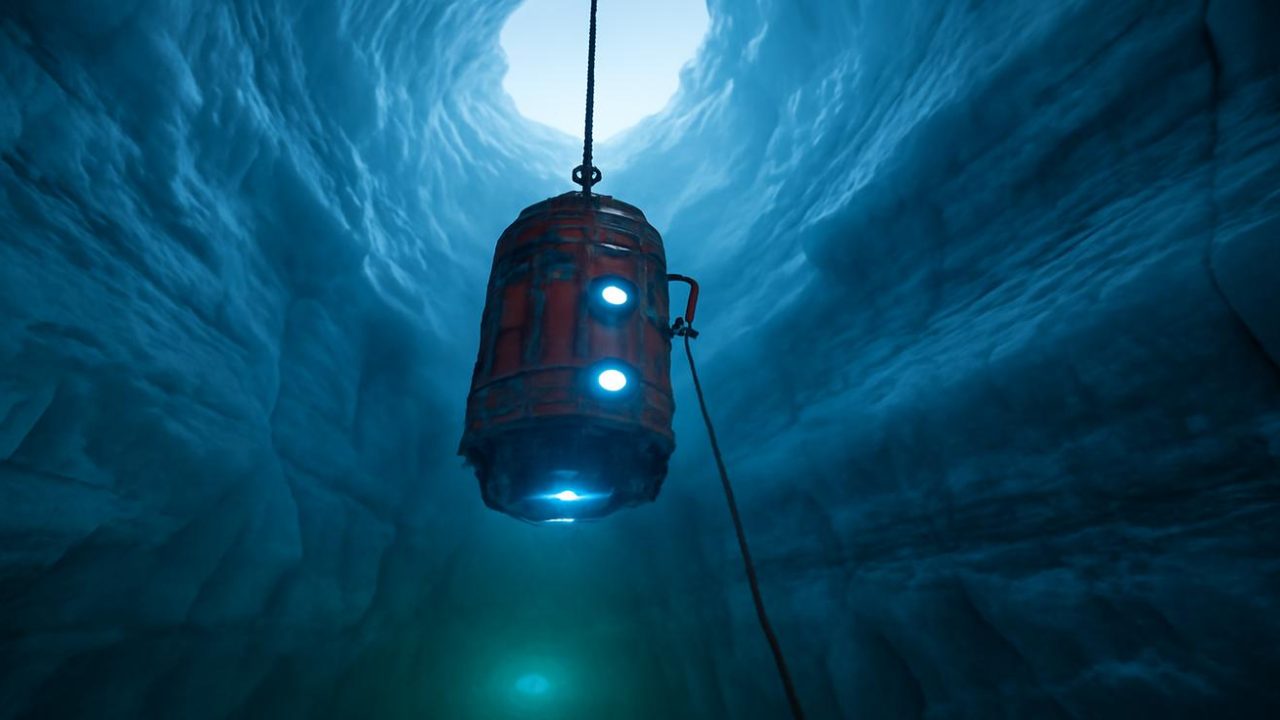
Operating in temperatures well below -20°C at the surface, researchers lowered Icefin through a borehole nearly a kilometer deep—almost the height of three Eiffel Towers stacked together. The robot descended into black water that had been sealed off by ice for thousands of years, hidden since mammoths still walked the northern plains.
What Icefin discovered in that alien world beneath the ice could reshape our understanding of how quickly Antarctica’s glaciers are destabilizing.

The Hidden Ocean Beneath Antarctica’s Ice
Under Antarctica’s massive glaciers lies a completely different planet. Icefin’s cameras revealed an underwater landscape carved into arches, shelves, and ragged hollows, stained in ghostly blues and greens. Some areas folded inward like the underside of a frozen storm cloud, while others appeared smooth and polished—a world-sized mirror pressed flat by unimaginable weight.
The robot operated as a wandering set of senses, its instruments constantly measuring temperature, salinity, and pressure. Its thrusters whispered through the water as it traveled along the base of one of Antarctica’s great outlet glaciers—ice streams that funnel the continent’s frozen interior toward the sea.
This underwater realm experiences no sunrise or sunset, only permanent midnight interrupted by the weak glow of artificial lights. There are no waves, no wind, no shore—only the dull groan of ice and the slow, relentless movement of seawater gnawing at the continent’s underbelly.

The robot’s eight-month journey focused on the grounding line, where glaciers lift from bedrock and begin to float. Scientists consider this area the hinge on which the future of global coastlines might turn.
What Scientists Fear Most About Grounding Line Retreat
The signal Icefin detected relates to what scientists call grounding line retreat—a phenomenon that sounds gentle but represents one of the most serious threats to coastal communities worldwide. This occurs when the point where a glacier meets the seafloor moves backward, allowing more ice to flow into the ocean.
The robot’s sophisticated sensors detected changes in this critical zone beneath glaciers like Thwaites and Pine Island—two of Antarctica’s most closely monitored ice streams. These glaciers stretch inland for hundreds of kilometers, moving toward the coast at only a few meters per year, but their underwater boundaries can shift much more rapidly.

Key factors that make grounding line retreat so concerning include:
- Warm ocean water can penetrate further under the ice as the grounding line retreats
- This creates a feedback loop where melting accelerates as more ice becomes exposed to seawater
- The process can become irreversible once it reaches certain thresholds
- Even small changes at the grounding line can affect massive amounts of ice upstream
The robot’s data provides unprecedented detail about how this process unfolds in real-time, offering insights that satellite observations and surface measurements cannot capture.
Advanced Technology Reveals Antarctica’s Secrets
Icefin represents a breakthrough in polar research technology. The sleek cylinder bristles with sensors, cameras, and delicate instruments wrapped in bright yellow casing designed to withstand extreme conditions.

The robot’s deployment required extraordinary logistics. It arrived by cargo plane, then traveled by snowcat to a remote field camp consisting of scattered tents, a communications tower, and a generator—the only signs of life on the vast ice sheet.
| Mission Parameter | Specification |
|---|---|
| Deployment depth | Nearly 1 kilometer through ice |
| Mission duration | 8 months continuous operation |
| Distance from open ocean | 3,000 kilometers |
| Surface temperature | Below -20°C |
| Drilling method | Hot water melting |
Researchers used hot water to drill through the ice, sending plumes of steam into the blue-white air. The drilling process took more than a day to create a shaft wide and deep enough to reach the hidden ocean below.
The robot’s instruments tick and blink continuously, taking measurements that help scientists understand how quickly conditions are changing beneath Antarctica’s ice. This data proves crucial for predicting future sea level rise and coastal flooding risks.

Global Implications of Antarctic Ice Loss
The changes Icefin detected beneath Antarctica’s glaciers have far-reaching consequences for coastlines worldwide. Even seemingly small shifts in ice dynamics can trigger massive changes in sea level over time.
Antarctica’s outlet glaciers act as natural barriers, holding back vast amounts of ice stored on the continent. When these glaciers destabilize, they can no longer effectively contain the ice behind them, leading to accelerated flow toward the ocean.
The robot’s findings help scientists understand the timeline for these changes. Previous estimates relied heavily on surface observations and computer models, but direct measurements from beneath the ice provide more accurate data about melting rates and ice dynamics.

Coastal communities worldwide depend on accurate predictions of sea level rise for infrastructure planning, flood protection, and emergency preparedness. The data Icefin collected during its eight-month mission contributes to more precise forecasting models.
Scientists note that the changes occurring at Antarctica’s grounding lines represent some of the most significant factors in global sea level projections for the coming decades.
What Comes Next for Antarctic Research
Icefin’s successful mission demonstrates the potential for long-term robotic monitoring beneath Antarctica’s ice. The robot’s ability to operate for eight months in one of Earth’s most extreme environments opens new possibilities for continuous observation of critical glacial processes.

Future missions may deploy multiple robots simultaneously to monitor different sections of Antarctica’s coastline. This would provide a more comprehensive picture of how ice loss is progressing across the continent.
The data collected during this mission will take researchers months or years to fully analyze. Each measurement helps build a more complete understanding of how Antarctic glaciers respond to changing ocean conditions.
Scientists emphasize that continued monitoring of grounding line retreat remains essential for accurate sea level predictions. The remote, harsh conditions beneath Antarctica’s ice make robotic exploration the most practical approach for gathering this critical information.

Advanced sensor technology like that carried by Icefin may become standard tools for climate research in polar regions, providing real-time data about changes that affect global weather patterns and sea levels.
Frequently Asked Questions
What exactly did the robot detect beneath Antarctica’s ice?
The robot detected signals related to grounding line retreat, where glaciers lift from the seafloor and begin floating, allowing more ice to flow into the ocean.
How long did the robot operate beneath the ice?
Icefin operated continuously for eight months, drifting three thousand kilometers from the nearest open ocean while taking constant measurements.
Why is grounding line retreat so concerning to scientists?
It can create a feedback loop where melting accelerates as more ice becomes exposed to seawater, potentially becoming irreversible and affecting massive amounts of upstream ice.
How did researchers get the robot beneath nearly a kilometer of ice?
They used hot water to drill through the ice, creating a shaft almost the height of three Eiffel Towers stacked together, then lowered the robot through this borehole.
What makes this robot different from previous Antarctic research methods?
Icefin provides direct, continuous measurements from beneath the ice for months at a time, offering data that satellite observations and surface measurements cannot capture.
How will this data affect predictions about sea level rise?
The robot’s measurements provide more accurate information about ice melting rates and dynamics, contributing to more precise forecasting models for global sea level changes.


Leave a Comment